Travels
Discovering Oregon’s South Falls
On Social Media I see a lot of images of places that I want to visit. Oregon’s waterfalls and geology features are saved to my google maps as “Want to Go There”. A mini vacation, had me driving East to West to visit family and I ticked off Silver Falls State Park off the list. Known for it’s Trail of Ten Falls, a 8 mile loop with many well, um… waterfalls. I didn’t have the time to hike the whole loop but made the short hike to South Falls.
From the parking lot, it’s about a mile, on a well paved path with several vantage points to view the falls. South Falls has a 177′ drop and is the tallest drop fall in the park. Visitors can walk behind the waterfall (if you look really close, you can see some people along the railing.)
For the image, I wanted to show the size of the basalt amphitheather with it’s flowing water cascading down into the bowl. This is 6 vertical photos and stitched together to create a pano.
Images from 2025
It’s been a while, I thought it’s a good time to revisit WordPress and share some of my best images from 2025. Most of my images here are panoramas (several vertical images taken in succession then digitally stitched together to create a long horizontal view of the landscape before me.)

I’ve always wanted to capture a sunset over Hot Creek Geological Site. It’s just past Mammoth Lakes along Hwy 395 in the Eastern Sierra. I decided last minute to drive about 2 hours in the pouring rain from South Lake Tahoe to get to this spot last August. I was fortunate that this particular spot was open and I could back up my car and wait out the passing rain for sunset. The fiery sunset never appeared but the storm clouds made this image just as moody as the weather outside. I guess I’ll just have to come back for that sunset photo.
Trona Pinnacles
I’ve heard a lot about Trona Pinnacles and seen some amazing photos from there as well. I was in SoCal over the weekend and decided a detour was in order for the day. Here are a couple of photos.

If you plan to head out there here are some suggestions. The road out there is washboard gravel. It’s a short bumpy ride, so a passenger car is do-able. (There were rv’s parked out there). Bring water, it’s early April and I was running around in shorts at 3 AM so stay hydrated & don’t forget the sunscreen. It can also get windy so be prepared to have dust in everything. There is one pit toilet and someone had left a lit citronella candle burning in there. Made for one of the most pleasant smelling pit toilets ever.
#28 Photograph Reflections
This week I pulled #28 from the Lightbox Photography Cards set. “The challenge here is to capture something of interest in a reflection”. Many iconic landscape photographs feature this technique. My samples this week are inspired by a recent trip to Oregon.


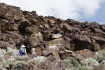
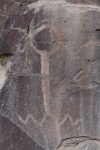
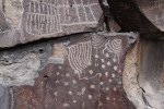
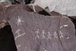
Lagomarsino Canyon, NV
Been back from my Southwest trip since early March. I had so many photos that I wanted to post from that trip that it’s taken me all the way into May. Now, for some shots from other adventures on the West Coast. Towards the end of March we ventured into Nevada to look for the Lagomarsino Canyon near Virginia City. Over 2000 petroglyphs have been recorded. The site is believed to be over 10,000 years old.


-

- Bring water


Tonto National Monument
The Southwest trip was ending and we drove the old Apache Trail (Hwy 188) to visit the Tonto National Monument. Here they have two cliff dwellings (one was closed) of the Salado people that lived in the Tonto Basin roughly 700 years ago. To get to the dwelling there is a steep path with switchbacks to get up the cliff. As I stood along the mouth of the entrance looking over the basin, I could only image how the people traveled throughout the area without modern conveniences.
Boyce Thompson Arboretum State Park, AZ
Spent part of a day at Boyce Thompson Arboretum State Park in Arizona last March.


Sunset Crater Volcano National Park
The rains had chased out of our intended destination, lava tubes near Flagstaff. We went for the next best option on the road to Phoenix – Sunset Crater Volcano National Park. Hard to believe that there was an active volcano just about thousand years ago in Northern Arizona.


Dino Tracks 1 Mile Ahead
During this trip I wanted to find some dinosaur tracks. I searched the internet for secret locations and imagined a long hike out in the middle of no where and then stumbling on a great find. It was towards the end of our trip and I was running out of opportunities. Then just outside Tube City, AZ there was a road sign, “Dinosaur Tracks 1 Mile Ahead”. We had time to kill and said “why not?!?” and pulled into the makeshift parking lot. The “tour” was by donation and Jennifer our guide told us that this land was Navajo lands and in their stories, no one came out there because of the ‘bones’. It was only a short time ago when they realized that the bones where dinosaur fossils. She grabbed a bottle of water (to highlight the tracks) and it was maybe 20 – 25 feet from the parking lot and you could see all the tracks.


Monument and Mystery Valley
Last day in Monument Valley and we took a guided tour of Mystery Valley.


